2027 Solar Eclipse Map: Path of Totality
The path of totality is the strip of Earth from which the Sun is completely covered. The map combines the sampled NASA path with calculations at individual coordinates. A wide regional illustration helps you choose a country; the exact point calculation determines whether your selected site receives totality.
Open the interactive 2027 eclipse map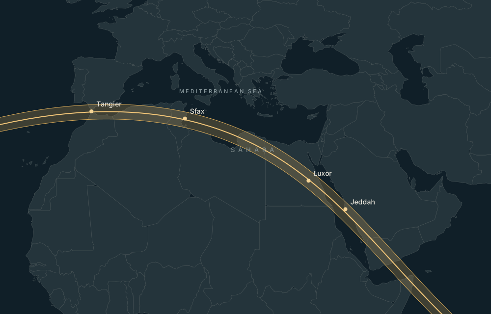
Follow the land route
Read the centre line and path limits
The centre line marks the middle of the shadow’s passage. Duration generally drops towards the limits, but changes along the route too. The site’s line distances are approximate; near an edge, use the calculated contact times and allow for the stated model limitations. A path line is not a boundary of public access or suitable ground.
Start with a known point, then refine it
| Location | Totality | Local maximum · 2 August 2027 | Centre-line distance ≈ | Historical daily cloud | Nearby airport |
|---|---|---|---|---|---|
| LuxorEgypt | 6m 21s | 13:05:12Africa/Cairo | 14.6 km | 11.8% mean150 days · 2016–2025 | Luxor International Airport (LXR)7 km straight-line |
| TangierMorocco | 4m 50s | 09:47:05Africa/Casablanca | 10.1 km | 12.2% mean150 days · 2016–2025 | Tangier Ibn Battuta Airport (TNG)11 km straight-line |
| JeddahSaudi Arabia | 5m 56s | 13:25:11Asia/Riyadh | 39.0 km | 39.6% mean150 days · 2016–2025 | King Abdulaziz International Airport (JED)15 km straight-line |
| BosasoSomalia | 4m 00s | 14:00:10Africa/Mogadishu | 89.7 km | 48.5% mean150 days · 2016–2025 | Bender Qassim International Airport (BSA)5 km straight-line |
| TarifaSpain | 4m 39s | 10:47:24Europe/Madrid | 34.6 km | 12.2% mean150 days · 2016–2025 | Jerez Airport (XRY)91 km straight-line |
| SfaxTunisia | 5m 40s | 10:11:35Africa/Tunis | 19.3 km | 13.8% mean150 days · 2016–2025 | Sfax Thyna International Airport (SFA)7 km straight-line |
Move from a town or monument pin to your actual position. Inspect the solar altitude and azimuth and run the terrain check. Buildings and vegetation need an on-site assessment. Map links retain coordinates so you can return to a location; the descriptive destination pages provide stable pages for reading and sharing.
Calculated astronomy uses NASA / Fred Espenak Besselian elements, a sea-level WGS84 observer and a smooth lunar limb. Historical weather is regional context, not a forecast. Airport routes, site access, travel advice and accommodation availability require current checks. Read the Sources & method.